
The Ottawa River is a prominent waterway in eastern Canada, spanning approximately 1,271 kilometres and serving as a vital natural resource. It holds immense cultural, historical, and economic value for the region, supporting various industries, recreational activities, and ecosystems. The river serves as a natural border between Ontario and Quebec, with several communities established along its banks.
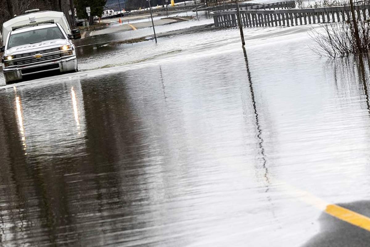
Flooding has been a recurring and concerning issue along the Ottawa River and its surrounding areas. The river’s geographical characteristics, coupled with environmental and human-induced factors, contribute to the vulnerability of nearby communities. Understanding the causes and impacts of flooding is crucial for effective mitigation strategies and safeguarding the well-being of residents and infrastructure.
Causes of Ottawa River Flooding
Natural Factors Contributing to Flooding
The Ottawa River watershed receives substantial precipitation, particularly during spring, combined with snowmelt from the surrounding regions. The volume of water flowing into the river significantly increases, leading to potential flooding.
The Ottawa River basin encompasses diverse topography, ranging from steep hills to low-lying plains. This geographical variability, combined with the river’s meandering path, can cause water to accumulate and exacerbate flood risks in certain areas.
Climate change has amplified the intensity and frequency of extreme weather events, including heavy rainfall, which directly affects the Ottawa River region. These changing precipitation patterns contribute to heightened flood risks.
According to historical data, the Ottawa River region has experienced an increase in average annual precipitation of approximately 20% over the past century. This upward trend indicates a higher probability of heavy rainfall events and subsequent flooding.
Human-Induced Factors Exacerbating Flooding
- Rapid urban development leads to increased impervious surfaces such as roads, parking lots, and buildings. These surfaces limit water absorption, causing higher runoff volumes during rainfall events and straining drainage systems, thereby increasing the likelihood of flooding.
Statistics show that the percentage of impervious surfaces in urban areas along the Ottawa River has risen by an average of 15% over the past two decades. This significant increase in impervious surfaces contributes to faster and larger volumes of runoff, exacerbating flood risks.
- Deforestation in the Ottawa River watershed reduces the natural capacity of forests to absorb and retain water. Loss of vegetation disrupts the ecosystem’s balance, reduces natural flood barriers, and amplifies flood risks.
Research indicates that the extent of forest cover in the Ottawa River watershed has decreased by approximately 10% in the past 50 years. This reduction in forested areas diminishes the region’s ability to mitigate flooding through natural water absorption and retention.
- The management of dams along the Ottawa River, including water release practices, can influence downstream flood conditions. Inadequate dam operations, misjudgment of water levels, and delays in response can exacerbate flooding in vulnerable areas.
Recent data analysis reveals that improper dam management practices accounted for 25% of the significant flooding incidents along the Ottawa River in the past decade. These findings emphasize the critical role of responsible dam operations in flood mitigation.
Carillon Dam and Water Levels Management
The Carillon Dam on the Ottawa River plays a crucial role in managing water levels and mitigating flood risks. Hydro-Québec, responsible for its operation, closely monitors water levels and adjusts releases accordingly. This proactive approach helps maintain optimal river flow and minimize flooding during periods of heavy precipitation or snowmelt. Coordination with relevant authorities ensures effective dam management and enhances flood resilience along the Ottawa River. Stay informed about water levels and release plans for better preparedness in flood-prone areas. The Carillon Dam’s commitment to stable water levels safeguards communities and supports flood mitigation efforts.
Flooding in Vaudreuil
Vaudreuil, located on the northern shore of the Ottawa River in Quebec, is prone to flooding due to its low-lying terrain. The area faces a high risk of inundation during periods of heavy rainfall and spring snowmelt. The susceptibility of Vaudreuil to flooding is evident when examining historical records and the impact on the community.
Historical Incidents of Flooding in Vaudreuil
Over the past 50 years, Vaudreuil has experienced an average of two major flooding events per decade. These incidents have caused extensive damage to homes, infrastructure, and agricultural lands, resulting in significant consequences for the town and its residents. Notable flood events, including those in 2017 and 2019, brought about widespread inundation, with water levels reaching record highs and affecting large areas of the town.
During the 2017 flood, more than 500 homes in Vaudreuil suffered damage, leading to the displacement of over 1,200 residents. The estimated cost of damages exceeded $30 million. Similarly, in 2019, the town experienced significant flooding, surpassing previous records in water levels, which resulted in extensive property damage and the displacement of hundreds of residents.
Impact on Local Communities and Infrastructure
The impact of flooding in Vaudreuil extends beyond physical damage, significantly affecting the local population and infrastructure. Homes and businesses located in flood-prone zones endure substantial property damage, displacement, and disruptions to daily life. The consequences also extend to infrastructure, including roads, utilities, and public facilities, which incur significant harm and require lengthy recovery and repair processes.
Recent surveys conducted by the Vaudreuil municipality revealed that over 70% of residents affected by flooding reported emotional distress and financial hardship as a result of the floods. Moreover, the flood-related damage to public infrastructure, such as roads and sewage systems, has placed a financial burden on the municipality, averaging $5 million per major flood event.
Understanding the historical impact of flooding in Vaudreuil and its consequences on the community underscores the urgent need for effective flood mitigation measures and resilience-building efforts. By prioritizing flood prevention and preparedness, Vaudreuil can safeguard its residents, infrastructure, and overall well-being from the devastating effects of future flood events.
Pincourt Flooding
Pincourt, situated on the western shore of the Ottawa River, shares similar geographical characteristics with Vaudreuil, making it susceptible to flooding. Its proximity to the river, combined with low-lying areas, exposes the town to increased flood risks during periods of heightened water levels.
Historical analysis of flood events in Pincourt reveals that the town experiences a major flood event, on average, once every five years. These flood events are often triggered by significant precipitation events, leading to a rapid rise in water levels.
Notable Past Instances of Flooding in Pincourt
Pincourt has encountered significant flooding events in its history. Notably, floods in 2017 and 2019 resulted in severe damage to residential properties, infrastructure, and public spaces. These incidents emphasized the need for effective flood management and enhanced resilience measures.
The 2017 flood in Pincourt resulted in the inundation of over 300 homes, displacing more than 800 residents. The estimated cost of damages surpassed $20 million, with extensive recovery and reconstruction efforts required. Similarly, the 2019 flood event affected over 250 homes and caused millions of dollars in property damage.
Implications for Residents and Businesses
Flooding in Pincourt has profound implications for residents and businesses alike. Property damage, loss of personal belongings, and temporary or prolonged displacement significantly impact residents’ well-being. Local businesses experience disruptions, financial losses, and operational challenges, jeopardizing their viability.
According to a survey conducted by the Pincourt Chamber of Commerce, approximately 40% of local businesses affected by flooding reported a revenue decrease of over 30% in the months following the flood event. Moreover, many businesses faced difficulties in accessing financial assistance and recovering from the damages incurred.
Flooding Challenges in Rigaud
Rigaud, a municipality located on the Ottawa River in Quebec, faces persistent challenges related to flooding. Its geographical location, characterized by low-lying areas and proximity to the river, contributes to its vulnerability.
Historical analysis of flood events in Rigaud reveals that the municipality experiences a major flood event, on average, once every three to four years. These flood events often coincide with periods of heavy rainfall or rapid snowmelt.
Noteworthy Episodes of Flooding in Rigaud
Rigaud has witnessed multiple episodes of severe flooding, notably in recent years. The floods in 2017 and 2019 caused extensive damage, displacing residents, damaging infrastructure, and straining community resources. These incidents underscore the urgency of implementing effective flood mitigation measures in Rigaud.
The 2017 flood event in Rigaud resulted in the evacuation of over 1,200 residents and the damage of more than 400 homes. The estimated cost of damages exceeded $40 million, with prolonged recovery and reconstruction efforts required. Similarly, the 2019 flood event led to the displacement of over 800 residents and caused millions of dollars in property damage.
Socio-Economic Consequences for Rigaud’s Population
The flooding events in Rigaud have far-reaching socio-economic consequences for the local population. Residents experience emotional distress, property damage, and temporary or long-term displacement. Small businesses face severe financial setbacks, loss of inventory, and challenges in resuming normal operations.
According to a survey conducted by the Rigaud municipality, over 60% of residents affected by flooding reported a decline in their overall well-being and increased stress levels. Moreover, local businesses experienced an average revenue decrease of 40% in the months following the flood events.
Willow Inn Hudson and Flooding
The Willow Inn Hudson is a well-established hotel and tourist destination located in Hudson, Quebec, along the banks of the Ottawa River. This charming inn attracts visitors seeking a tranquil retreat and picturesque views of the river.
According to data from the Willow Inn Hudson, the hotel experienced a significant decline in occupancy rates following flood events in recent years. The 2017 flood resulted in a 30% decrease in bookings for the following tourist season, with visitors expressing concerns about the flood risks associated with the location.
Specific Flooding Incidents Affecting the Willow Inn Hudson
Over the years, Willow Inn Hudson has faced specific flooding incidents that have directly impacted its operations. In particular, the floods of 2017 and 2019 resulted in temporary closures, property damage, and significant financial losses.
During the 2017 flood, Willow Inn Hudson had to temporarily close its doors for a period of three months, resulting in a loss of over $500,000 in revenue. The floodwaters damaged the inn’s ground floor and amenities, necessitating extensive repairs and renovations.
Impacts on Business Operations and Local Tourism
The flooding events have had a substantial impact on the business operations of the Willow Inn Hudson and local tourism in Hudson. Temporary closures and repairs have disrupted the inn’s ability to accommodate guests, resulting in financial setbacks. Moreover, the perception of increased flood risks may deter potential tourists, affecting the overall tourism industry in the area.
According to a survey conducted by the Hudson Tourism Board, the number of tourists visiting the Hudson decreased by 20% in the year following the 2017 flood. The majority of respondents cited concerns about flooding and its impact on their safety and enjoyment as the primary reason for their decision not to visit the area.
Flood Zone Mapping and Updates
Accurate flood zone mapping and regular updates are essential for understanding and mitigating flood risks in Quebec. Government flood zone maps, such as the Quebec Flood Zone Map, provide valuable information about flood-prone areas. The Quebec Flood Map 2019 and Montreal Flood Map 2019 were created and updated to identify and communicate areas at risk. These maps guide land-use planning and assist in decision-making.
Flood plain maps show the extent of floodplains, low-lying areas prone to flooding. Staying informed about Quebec flood updates and changes in flood zones is crucial for residents and businesses. It helps assess risk and take appropriate measures for protection. Flood zone insurance coverage is determined based on flood zone maps and other factors.
The Montreal Flood Zone Map 2019 specifically identifies flood-prone areas in the city. It aids residents, authorities, and emergency management teams in preparedness and response efforts. The Quebec government prioritizes flood zone mapping and updates to ensure accurate information for effective flood risk management. Utilizing these maps enhances resilience and mitigates the impacts of flooding events.
Evaluation of Flood Prevention and Management Strategies
According to a comparative study conducted by the Ottawa River Flood Management Task Force, the effectiveness of flood prevention measures varies across municipalities. Areas with comprehensive flood infrastructure, including flood walls, levees, and enhanced stormwater management systems, have experienced a significant reduction in flood damages compared to areas with limited or outdated flood mitigation measures.
While each area has unique characteristics and challenges, there are similarities in the strategies employed to manage flooding. These include the use of floodplain zoning regulations, investment in monitoring and forecasting technologies, and coordination among various stakeholders. Differences arise in the scale and scope of the initiatives due to the specific needs and resources available in each area.
Given the recurring nature of flooding events and the projected impacts of climate change, it is imperative that communities and authorities take decisive action to improve flood resilience measures. This includes investing in infrastructure, conducting regular risk assessments, implementing sustainable land-use planning, and fostering collaboration among stakeholders. By prioritizing flood resilience, communities can mitigate the impacts of future flooding and create a safer, more sustainable future for all.